Tropical Disturbance WP54 (91W)'s potential development into a Tropical Cyclone within the next 24 hours is now UPGRADED from Likely to HIGH, now with 73% chance. -- ManilaTC 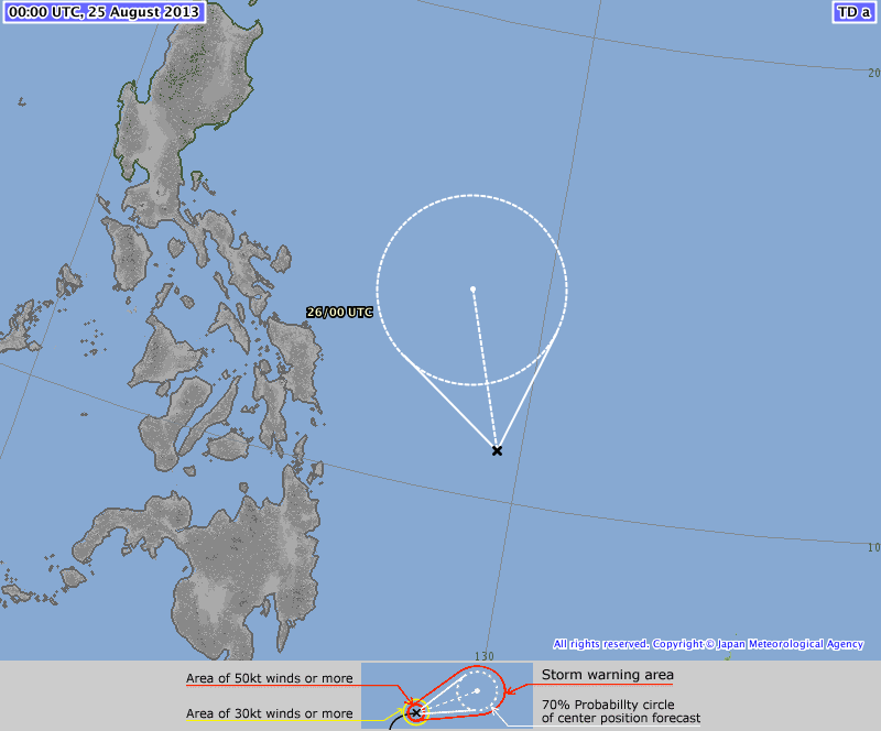 The Japan Meteorological Agency has upgraded WP54 (91W) as a full Tropical Depression, moving North-Northwest at 7kph.
** WTPQ20 RJTD 250000 *** RSMC TROPICAL CYCLONE ADVISORY NAME TD ANALYSIS PSTN 250000UTC 11.0N 129.5E POOR MOVE NNW SLOWLY PRES 1004HPA MXWD 030KT GUST 045KT FORECAST 24HF 260000UTC 14.2N 128.3E 120NM 70% MOVE NNW 09KT PRES 996HPA MXWD 035KT GUST 050KT ManilaTC is now issuing a Tropical Cyclone Formation alert for Disturbance WP54 (Invest 91W) located east of Samar province.  Tropical Disturbance WP54 (Invest 91W) has shown further organization and is now subject to a Formation Alert by ManilaTC. At 0200am today, WP54 (Invest 91W) was last located at 10.9°N, 130.8°E... about 550km East of Guiuan town in Eastern Samar, Philippines. Maximum winds near the disturbance center are at 35 kph (20 kts), and has drifted to the Northwest to Computer models are in unanimous agreement to develop WP54 (Invest 91W) into a tropical cyclone within the next 24 hours and to track Northwest across the Northern Philippine sea... potentially towards Extreme Northern Luzon. Should PAGASA upgrade this disturbance, it will be named Nando. ManilaTC analyzes that Tropical Disturbance WP54 (Invest 91W)'s potential development into a Tropical Cyclone within the next 24 hours is LIKELY, with 63% chance. #ManilaTC #TyphoonWatch #HabagatWatch #StormWatch |
Archives
July 2016
AuthorThis is the official blog page of Manila Typhoon Center. All the latest advisories from ManilaTC will be coursed here should the Facebook page be inaccessible for any reason. Categories
All
|
Manila Typhoon Center - Your online resource for typhoon updates.
 RSS Feed
